Central Meteorological Observatory: Typhoon Kanu will land in South Korea and move towards China. Northeast China should be alert to the superposition effect of heavy rain.
CCTV News:According to WeChat official account news from the Central Meteorological Observatory, the latest forecast of the Central Meteorological Observatory predicts that the No.6 typhoon "Kanu" will land on the south coast of South Korea on the morning of August 10th and enter the northeast of China on the night of the 11th, bringing strong wind and rain. There are 6 ~ 7 winds in parts of Heilongjiang and Jilin, and local gusts are 10 ~ 11; There are heavy rains in northeastern Jilin and southeastern Heilongjiang, and the accumulated rainfall can reach 120 ~ 200mm. The cumulative surface rainfall in sub-basins such as Mudanjiang, the lower reaches of Songhua River and Tumen River is 75 ~ 85mm. Meteorologists reminded that the future wind and rain affected areas of Typhoon Kanu are highly overlapped with the areas where heavy rains and floods occurred in Heilongjiang and Jilin provinces in the early stage, and the pressure of flood control is great. It is suggested to take precautions against floods, mountain torrents, geological disasters and urban and rural waterlogging in small and medium-sized rivers in advance.
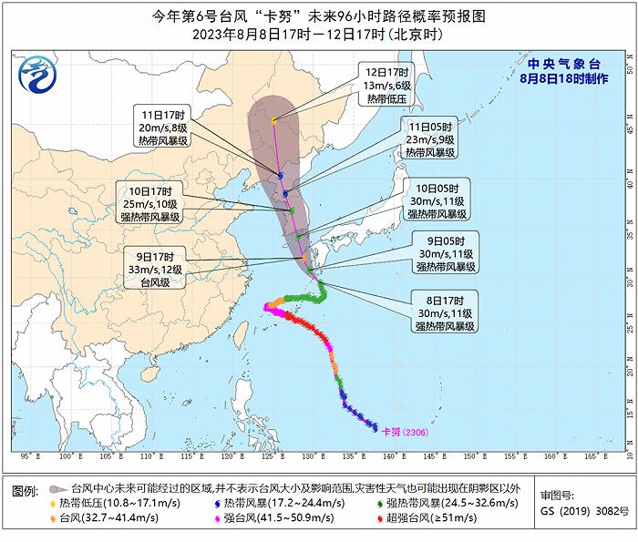
It is estimated that the No.6 typhoon "Kanu" will move northward at a speed of about 10 kilometers per hour this year, and its intensity will be enhanced. It will land on the southern coast of South Korea on the morning of August 10, and its intensity is expected to be strong tropical storm or typhoon (28 ~ 33 m/s, 10 ~ 12), and it will enter the northeast of China on the night of the 11th, and gradually weaken into an extratropical cyclone.
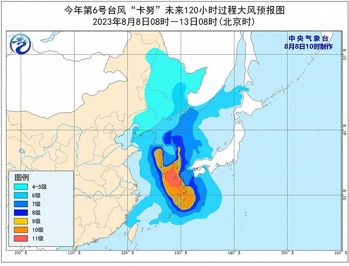
Gale forecast: It is predicted that there will be 6-8 winds and 9-10 gusts in eastern Bohai Sea, Bohai Strait, Yellow Sea, East China Sea, Taiwan Province Strait, southern coast of Zhejiang, northern coast of Fujian and northern coast of Taiwan Province Island on August 11th, affected by Kanu. Among them, the winds in the eastern part of the Yellow Sea and the eastern part of the East China Sea can reach 9-10 and the gusts are 11-10. On October 10-13, there were 4-5 winds and 6-7 gusts in the northeast and coastal waters of Shandong Peninsula, 6-7 winds and 8-9 gusts in some areas of Heilongjiang and Jilin, and the local winds could reach 8-9 and 10-11 gusts.
Rainfall forecast: On October 10-12, affected by Kanu, there was moderate to heavy rain in eastern Liaoning, and heavy rain in eastern Jilin, northern Heilongjiang and central and eastern China, including heavy rain in northeastern Jilin and southeastern Heilongjiang. The accumulated rainfall in the above areas is 30 ~ 60 mm, and the local area can reach 120 ~ 200 mm. The maximum hourly rain intensity is 30 ~ 50 mm, and the local area can reach more than 60 mm. The main rainfall period is from the night of the 10th to the day of the 12th.
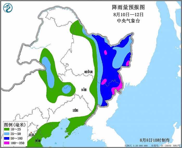
Surface rainfall forecast: on October 10-12, the surface rainfall in the sub-basins of Songhua River, such as Hulan reach, Lalin reach and Songhua Lake, is 22-28 mm; The cumulative area rainfall of Mudanjiang, the lower reaches of Songhua River and Tumen River is 75 ~ 85 mm..
Experts remind that since the end of July, there has been heavy rainfall in Northeast China, with rainfall in most parts of Heilongjiang, western Jilin and southern Liaoning being 30% to 80% higher than normal, and in some parts of southeastern Heilongjiang, northern Jilin and western Liaoning being more than twice as high, resulting in super-warning floods in many rivers, and heavy rains and floods in Lan Shu, Jilin, Wuchang and Shangzhi in Heilongjiang. Because the future wind and rain impact of Kanu is highly overlapped with the previous falling area, the disaster risk will be further aggravated, so it is suggested to do a good job in flood control in Songliao Basin. The bottom water of rivers in Heilongjiang and Jilin is high, so it is necessary to pay attention to the monitoring of rain, water and flood, strengthen the inspection of dams and dams in rivers, reservoirs and lakes to ensure the safety of small and medium-sized rivers, reservoirs and towns, and strengthen the prevention of disasters such as flash floods, landslides and mudslides in mountainous areas.
In addition, it is estimated that on October 10-12, the risk level of farmland waterlogging disaster in some areas such as central and eastern Heilongjiang and eastern Jilin is high, which has adverse effects on the growth and development of crops such as spring corn, soybeans and potatoes. It is suggested to clear ditches and drain water in time to reduce the risk of crop lodging.